Nature’s earthquake library — sediment records of past earthquakes
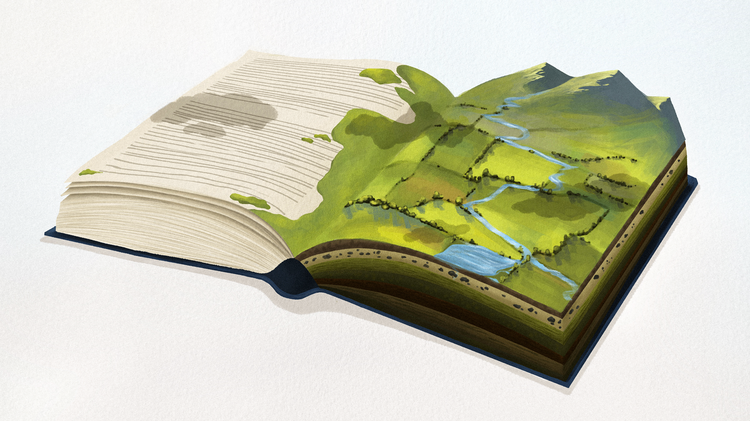
Nature has witnessed every earthquake, and it takes notes of the strongest ones, generally those above magnitude 6. These notes are not captured in words, but in sediments: rock or soil that was eroded, transported and deposited in a new location during the earthquake or immediately after it — like ink pressed onto the pages of a book. Unearthing this evidence, often older than written history, is a science called paleoseismology. Much like restoring old or damaged books that got soaked, some passages smeared beyond recognition and pages sticking together. But when enough pages and chapters are made legible, the narrative emerges. By deciphering sediment records we can learn how often earthquakes occur in a region and how large they were. This is invaluable information for improving our resilience and preparedness for seismic hazards.
My research in Ngā Ngaru Wakapuke focuses on traces of prehistoric earthquakes on faults of the plate boundary transition zone in central Aotearoa New Zealand. In the northern South Island I am searching for well-preserved manuscripts — sediment records in nature's earthquake library — easy to read, reaching far into the past and missing no chapters.
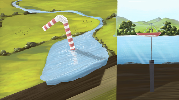
Lakes are among the most reliable authors, taking notes of strong earthquake shaking in the submerged sediments. Under normal conditions, fine sediment grains gradually settle to the bottom, continuously accumulating layer by layer. When seismic waves strike, the calm accumulation is interrupted. Underwater landslides flow into deeper parts of the lake. Soft sediment layers are fractured and folded. The sediments are disturbed, eroded, transported and deposited in a deeper part of the lake. What remains is an ‘event layer’ that is sealed beneath the mud that gradually and quietly settles on top of it.
Studying these records is slow, methodical work. We start with extracting sediment cores from the deepest parts of the lake — plastic pipes of a few meters length that are lowered to the lake floor and hammered into the sediment. Before retrieval, a mechanism seals the top of the barrel to keep the sediment in place. The principle is simple: just like submerging a straw in water, sealing the top with your finger, and lifting it out — the water stays in the straw — the same happens with the sediment in the core.
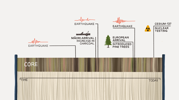
One of the most exciting moments of my research is the lengthwise splitting of the cores — like notes that have been taken thousands of years ago, but nobody has ever read them. Paleoseismologists can sometimes identify earthquake layers on the first look, but often we need additional methods to understand what happened. For example, we scan the cores using a CT-scanner, which allows us to visualise changes in density and internal structures and see folds or fractures, in three dimensions.
Once restored, the pages of a book must be in the right chronological order for the book to make sense. Luckily, some sediments contain time markers such as the radioactive fallout peak from nuclear weapons tests in the 1960s or shifts in vegetation linked to the arrival of European settlers in the mid-19th century. When I want to date an earthquake’s ‘event layer’, I take samples above and below it, rinse off the fine mud, and search for plant fragments under the microscope. Leaves or twigs are ideal targets for radiocarbon dating. With multiple ages along the core, I can determine the timing of an earthquake to within a few decades.
A single lake records shaking at one location. When we find an event layer in several lakes at the same time, it is likely that the earthquake shook a wider area. With this regional information we can estimate the size of the earthquake and sometimes which fault likely ruptured. However, in the transition zone many faults are closely spaced leaving many options when we try to link the shaking records to faults.
To be confident about which fault ruptured at what times, we study sediments on, or adjacent to, the faults. Those records are different — like books written in different languages. Growing up in Italy, speaking German at home and English at work, I am used to adapting my language to the environment. In my research I need to adapt the approach for each paleoseismic archive in order to read it. Trenches dug across a faultline can expose traces of past earthquakes, but gaps in deposition or erosion can limit the record length and hinder precise dating. For this reason, I currently focus on lakes and wetlands situated on or near faults. There, the continuous accumulation of sediment over thousands of years can preserve long and well datable records. Fault slip can trigger underwater landslides, a lake tsunami, or dam a stream that temporarily floods a wetland, leaving clear changes in the sediment record that we can date and link to the adjacent fault.
Ultimately, all pieces of evidence are combined — putting the books in the right shelves of the library, based on language, genre and author. This allows us to understand the most significant parts of the earthquake history, to get an idea of what to expect in the upcoming chapters.
Markus Niederstätter is a PhD student at Victoria University of Wellington studing the seismic imprints in lakes, wetlands and trenches to establish on- and off-fault paleo-earthquake archives that span several thousands of years.
Jean Donaldson is an illustrator and designer at Toi Āria: Design for Pubic Good. She has a passion for using illustration and creativie communication to share science and complex information in ways that are accessible and engaging to a wider audience.